Starina (Sztarina, Cirkokaofalu)
We have very little information about this village. If you would like to contribute knowledge or material about this village, please drop us a note.
Highlights
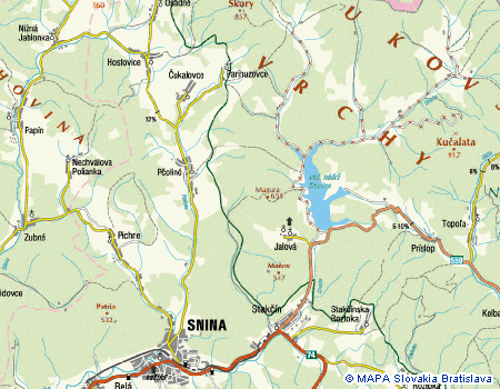
History This village was evacuated in 1980 as it was in the watershed area for the construction of the Starina Reservoir. One building and the cemetery remain.
Situated in the Cirocha river valley, the village is mentioned for the first time in the 1557 as a Humenné Estate possession. In the 18th century it belonged to the noble family Roll, passing then to the Révészy family, and later to the Ocskay family. A mill was constructed in 1715. Throughout its history, its inhabitants were employed as woodsmen and coalmen.
The church, was of Baroque decoration, originated in 1775. It was removed in 1980.
Source: Vlastivedný Slovník Obcí na Slovensku Bratislava 1977
1557 Ztarina, 1773 Staryna, 1786 Starina. Situated in the Cirocha river valley, the village is mentioned for the first time in the 1557 as the town Humenné possession. In the XVIII century it belonged to the Roll, the Révészy, and the Ocskay families. It got a mill in 1715. During the History, its inhabitants were occupied as woodmen and coalmen. Source: Roberto Cannoni, Italy PhotosCemetery Photos by Juraj Cisarik Rusyns - Lost Homes - A picture essay of the land of the seven villages cleared to make way for the Starina Reservoir. SurnamesLinks to off-site webs will open in a new window. Please disable your pop-up stopper. Last Update: 15 November 2020 Copyright © 2003-2021, Bill Tarkulich | |||||||||||||||||||||||||||||||||||||||||||||||||||