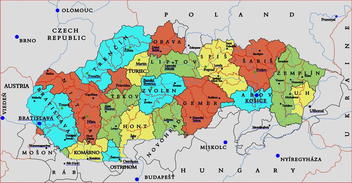
Maps of Slovakia & Environs Recommended for Genealogical Research Contemporary | Historical | Place Names | Military | Place Name Terminology The territories of present-day Slovakia were a part of Hungary for nearly 1,000 years, until the conclusion of World War I, which resulted in the demise of the Austria-Hungary Monarchy. The Hungarians used their own language of Magyar to denote the names of settlements. Researchers quickly learn that their village had multiple names over time. The largest emigration occurred during the Hungarian rule, This is why so many Hungarian maps are included in this reference. In 1910 the Magyar language was "modernized". After World War I (1918) only the territory remaining in Hungary retained Magyar names. As a general guideline, before 1910, villages used Magyar names and after 1918, villages reverted to the local / indigenous place name. Keep this fact in mind as you compare maps created before and after these dates. Contemporary Maps - Online
Contemporary - Paper Maps - appropriate for Genealogical Research If you're in the market for maps for use in your research, the VKU Hiking Map and VKU Podrobny Auto Atlas will serve you well and you will need no other. The spiral bound Atlas is good for the armchair researcher, providing sufficient detail to capture the entire country of Slovakia. You'll be able to identify churches, hills, streams, most major features. It also doesn't miss a single road in the nation. The atlas is also a terrific auto navigation tool. The Hiking/Tourist foldout Map has twice the precision of the Atlas. It describes most buildings and structures, along with paths and detail topographical markings. Great if you're trying to determine how adjacent villages may have interacted long before autos and buses.
For genealogical research in our region, I direct your attention to historical maps. Remember that if your village is in the borderlands, it may be useful to examine maps of neighboring countries/territories. Most country maps show the borderlands of neighboring villages for a good 25 to 50 KM into the neighboring country. Caution! Most online maps are sizeable files. Downloads can be slow, depending on your connection. Sites in Hungary only add to the lethargy. Do not let this dissuade you however, your wait will be rewarded. For future reference, it is suggested that you save the map to a file on your local computer to avoid unnecessary re-downloading. Historical Maps - Online HUNGARY (To 1918 & Transitional) - Historical
Slovakia (First Republic 1938-1944) - Historical
Austria, Province of Galicia (present-day Poland, parts of Ukraine) - Historical This region borders northern Slovakia Ukraine - Historical This present-day Ukraine region borders Eastern Slovakia and incorporates the: a) pre-1918 Hungary Ung, Mamaros, Bereg and Ugocsa counties, b) former 1918-1939 Czechoslovakia territory of Zakarpasta/Subcarpathia/Ruthenia and c) the inter-WWII territory Hungarian territory called Carpatho-Ukraine. Note: There are better places to find these historical maps of Eastern and Central Europe. I have not yet spent the time learning how to navigate through them, but both repositories contain the maps referenced below. 10/2020, BT
Place Name Research Database & Maps - ShtetlSeeker An amalgam of old place names, current place names with present-day Mapquest link. Useful in locating an old village name to a current location. Allows a radius search from any geographic coordinates, great for locating nearby villages without needing a map. Old place name list is incomplete. Includes all Eastern European nations. HIGHLY RECOMMENDED WHEN IMPRECISE VILLAGE NAME OR SPELLING IS KNOWN. Eötvös Loránd University Faculty of Science Department of Cartography (Hungary web site) Excellent Hungary-based collection of historical maps of Hungary. Publishers of 1907-1927 Hungarian County Maps. Paul Magocsi's "Historical Atlas of East Central Europe" is a definitive work. Rather high-level, doesn't show every village, but provides an excellent overview of how history changed the borders of this region. Format: Paperback, 218pp. ISBN: 0802077897 Publisher: University of Toronto Press Pub. Date: January 1996 $45.00 (2004)
ATLAS AND GAZETTEER OF HISTORIC HUNGARY 1914, Talma Publishing, Hungary Great county-by county maps of entire Hungarian Empire circa 1914-17. Index of all villages along with 1914 census data: population, ethnicity and religion. Magyar place names only. In Magyar.
1910 Hungary Military Maps Covers the entire kingdom - High Resolution. (offsite)
1939-1945 Soviet Battle Maps from RKKA in World War II Site Very high detail. Originally created by the Soviet Army (RKKA), scanned in here. Nice maps from a Soviet perspective. Shows fairly detailed positions of regiments over a number on a daily basis. Primarily illustrates Soviet formations, not much shown on German positions. Includes actions in Poland, Ukraine and Slovakia. First maps of such detail I've seen posted on the web. An important find.
1938-1945 World War II European Battle Maps from the US Military Academy at West Point Published by US military college, a fairly high-level, regional perspective. Shows major armies and fronts on a monthly basis. Fairly balanced presentation, showing troops on both sides of each conflict.
Post-Dukla East Slovakia Advances, Oct-Nov. 1944 Battle Maps - Animated Progression - Hungary Site
Links to off-site webs will open in a new window. Please disable your pop-up stopper. Last Update: 15 November 2020 Copyright © 2003-2021, Bill Tarkulich | ||||||||||||||||||||||||||||